Saturday, July 26, 2014

What happens to Earth's Mycorrhizal Community when their Hosts fail above ground ?

"You don't have to inoculate because spores are  found everywhere in the Air."  Oh but I beg to differ, yes it does matter!
image: John Upton

Discover magazine published an excerpt from biologist Edward O. Wilson’s recent book The Diversity of Life, in which he listed the extinction of thousands of species of birds, fish, and insects, as well as species usually dismissed as unimportant: 

“Many of the vanished species are mycorrhizal fungi, symbiotic forms that enhance the absorption of nutrients by the root systems of plants. Ecologists have long wondered what would happen to land ecosystems if these fungi were removed, and we will soon find out.”

A pine seedling roots flush with mycorrhizal fungi,allowing the plant to
obtain nutrients from a bigger volume of soil.
Image from David Read, author of Mycorrhizal Symbiosis.

It's almost impossible to believe that mycorrhizal Fungi themselves are in danger of massive deterioration and possibly extinction in some areas of the Earth, especially when the prevailing faith affirmation is that "Fungal spores are just everywhere in the air". In other words, don't worry, it'll be fine. I often hear this [mainly by native plant nursery experts who are supposed to be in the know] when I reveal to them that I always inoculate even when I suspect microbial life in the ground is healthy. I just refuse to not take a chance, and besides, there are some species of fungi which are superior in starting a plant out successfully than others do. I'm not trying to be cute here, but there's more to the story. Like everything else, Micro-organisms are not immune to human idiocy. So no it's not invincible as we once thought, or at least not anymore. Does it stand to reason that if plant life above the ground earth wide is suffering and in severe cases failing, that the conditions underground, just possibly the microbial community isn't doing so hot as well ? More and more there is scientific evidence that this just may be the case. It's always been a given that for the most part, where ever in the world's cities , Humans use massive amounts of science-based chemical Fertilizer solutions and other deep tilling practices have been employed, the microbial community is either limited or entirely gone. Further, when areas of an agricultural landscape are plowed up near the surface, this will often kill off the mycorrhizal network, and made even worse with the chemical fertilizer applications. In the post I did on the habitat restoration project at Thousand Palms oasis where it was necessary to physically remove Tamarisk trees, two types of method were employed in the removal and as noted, there were two stark contrasts in results of plant community response.
"Most areas were cut by hand, thereby selectively cutting out the tamarisk while leaving the native shrubs unharmed. Only a 7.5 acre (3 ha) section that was heavily infested (> 95%) was cleared using a bulldozer." 
"In the 7.5 acres (3 ha) that was bulldozed, natives established much more slowly than in the hand-cleared areas." 
(Source) "A Success Story Tamarisk Control at Coachella Valley Preserve, Southern California" 
Did you notice that the method in which the crews hand removed the invasive vegetation, but left the other native shrubs intact ? These regions were reported to have recovered faster. The Bulldozed land which was stripped entirely and replanted recovered far more slowly. This method is often employed by the US Forest Service in replanting Timber species Pine trees and success is much slower than leaving some chaparral intact. While they make no mention of the mycorrhizal grid, no doubt this was obliterated at the Bulldozed location at the time of disking and scraping. I also found this in my own case where I always hand removed only a handful of chaparral when planting trees and leaving much of the ecosystem intact. But something else is going on now that is causing the mycorrhizal network to fail in many areas. The really scary thing now is that this disappearance phenomena may also be happening in many of the Earth's wildland areas and not limited to those regions disrupted by Humans. But why is this ? 
~~~~~~~~~~~~~~~~~~~~~~~~~~~~~~~~ 
Major Groundwater Deficit Out West Might Hold Some Clues
image: Earth Observatory - NASA
The people at NASA came out with a map just a couple of days ago referencing groundwater deficits especially out in the western states. Here is what they said:
"Long-term drought and aggressive seasonal wildfires have consumed property, lives, and farmland in the American West. The dry weather and blazes are battering regional economies and putting residents and agricultural businesses in several states on a path toward water restrictions. At least part of this story of water woes lies underground."
"The map above combines data from the satellites of the Gravity Recovery and Climate Experiment (GRACE) with other satellite and ground-based measurements to model the relative amount of water stored in underground aquifers in the continental United States. The wetness, or water content, is a depiction of the amount of groundwater on July 7, 2014, compared to the average from 1948 to 2009. Areas shown in blue have more abundant groundwater for this time of year than comparable weeks over the long-term, while shades of red depict deficits compared to this time of year." 
~~~~~~~~~~~~~~~~~~~~~~~~~~~~~~~
Many Native wildland Plant Communities are in major decline or out right dying, Why is this ?

Anza Valley viewed north @ Thomas Mountain off
Mitchell Rd & east of Kirby Rd next to Agri-Empire Well (2014)
The photograph above was taken in a northerly direction from a commercial well head owned by Agri-Empire just north of the dirt road part of Mitchell Road and east of Kirby Road. What caught my attention here, and this had been seen elsewhere, the Parry Pinyon Pines are failing all over the place. Believe it or not I actually wrote about what was going to happen back in early 2013 before I came over that Spring. I already was aware of Parry Pinyon's decline and some of the efforts to help save these trees within the San Jacinto Mountain range. The account from the Press Enterprise falsely cursed and demonized Chaparral as hindering the successful life of Parry Pinyon. But the efforts of their chaparral clearing programs were less than successful, especially given the lack of knowledge by well meaning people who were in a position of authority to have known better how specific ecosystems [like Pinyon/Juniper woodlands] actually work. The leadership should have known better:
Little Did I Know at the Time, Parry Pinyon was only the Beginning! 
Any Pinyon and especially the Parry Pinyon,  has always been one tough tree. But like other living things, this tree also has limits as to what it will endure. Historically they have always germinated newer trees with great ease, especially on a steep southern facing slopes of Thomas Mountain to the Anza Valley floor which is dominated by Chamise or otherwise known as Greasewood. Not many trees would tolerate such a habitat. These trees in this area for example have always produced 1000s of pine nuts per year and it could be observed that 100s of seedlings emerged successfully after germination over Winter, whether they made it through the first year or not. The above photo isn't the best close up shot I could get, but I had a delicate Rental Car that was never made for the offroad. From a distance however you could see numerous skeletal outlines of the Parry Pinyon tree silhouettes. Many Pine trees will normally shed leaves or needles from oldest years to the newest during times of drought stress. Most of the pines at my old place still contain needles which go back 5 or 6 years, but many of these Parry Pinyon trees had only two years worth of needles which reveals their present drought stressed struggle for life. Some were outright dead which can be seen from a drive along Hwy 371 leaving Anza Valley heading to Paradise Corners. This unfortunate observation is just not normal, especially for these Pinyons up there around Anza. Of course all the Coulter and Jeffrey Pine are being effected as well. That entire southern face of the eastern end of the Thomas Mountain chain had always attracted my attention because the trees always stood out in stark contrast to the surrounding Chaparral plants. Now you can't even tell the difference. But one wonders what has happened to the mycorrhizal fungi community under the ground which normally is the foundational support of the above ground ecosystem. Why isn't it not up to the task of it's assigned  job ? Let's see how it works when all pistons are firing.

The foundation of every single ecosystem on Earth is the fungi community. Depending on the system, the variety of plants and animals living within that system are determined by the health of the microbial system of the fungi along with the right kind of beneficial bacteria. The foliage mechanisms of all plants that are above the ground act as factories which produce energy from the sun, manufacture food and allow the plant to reproduce. The mycorrhizal community under the ground draw off the nutrition the plant manufactures in the form of simple sugars or carbohydrates which the fungi are incapable of producing on their own. Obviously the Fungi provide generous amounts of raw materials in the form of water and nutrients in exchange for the food the trees and shrubs generously provide. An important factor in all of this working together and cooperation is available moisture which provide the major support in this cooperation. Look at any shrub or tree this way, think in terms of purchasing a factory stock muscle car from the 1960s. Certainly the vehicle has many outstanding qualities on it's own and will perform just fine. But this vehicle can be further enhanced by modification of the cars various mechanical components which relate to higher performance. The fungal community under the ground acts as just such a modification partner. They provide an energy performance to helping out the plants during the rougher  times. They provide an antibiotic system which protects plants root infrastructure from diseases which would otherwise wear down it's mechanical components. They create a sharing interconnection exchange of nutrients and moisture between the entire the plant community, and create a much larger resource base by which further moisture and nutrients can be drawn from a greater area. If any of the modified components shut down for any reason, then the entire system can be effected negatively.
It is the same with any vehicle. If the  header exhaust system, gears, or the high performance carburetor starts to fail for any reason, the entire system suffers. With the plant world, we are now seeing complete failure in many places. This is true for example in Anza California. Off hand I'd say it's the inconsistent rainfall totals I have been following throughout Southern California over the past couple of years. Totals are extremely uneven with some areas getting doused with rain and others receiving only a trace. This past rainy season especially, most totals are extremely way down throughout California and this downward trend has been getting worse over the last few years. Seasonal rainwater and other forms of moisture to an ecosystem are like what gasoline is to a car. Lack of water will also create and cause total shutdown in most plant ecosystems, and all other life will be likewise effected. People aren't the only ones with a stake in this water crisis emergency.

What I noticed this past rainy season is that even if an area was officially recorded as receiving an inch of rain, other storms that followed were few and far between. An inch of rain doesn't soak very deep, especially when it's not followed up by other rain amounts. The sun and wind dry up what was made available and the pores in the soils seizes up tight once again. No amount of moisture build up is allowed, which explains why invasive weeds didn't even do well in these areas this past year. The ground water availability chart above provided by NASA bears this out. Most of the chaparral I saw on my trip hadn't even put on a new season's growth, which tells me they are in survival mode at any cost. When this happens, plants and trees will either restrict or hinder altogether giving any carbohydrates to their mycorrhizal partners in life. The plants right now are in extreme survival mode when they shut down and don't produce. Many go drought stress deciduous. For the past decade I have not once found PT Mycorrhizal Truffles in either my favourite wild collecting spots not specific places within cities which were colonized.
image: Roger Gosden
In every ecosystem around the globe there are ecological switches that exist which push the system through a succession of changes until maturity is reached, and the same could be true in reverse when the ecosystem begins to collapse as a result of disturbance from the norm. Reverse engineer anything and you notice a gradual breakdown. Seriously, look at Earth's Climate mechanisms. If we go back to our automobile comparisons, fast forward to our present computerized run modern cars which are loaded with sensors which send instantaneous signals to the computer's programming brain which continually monitors temperature, timing, fluid levels, etc, etc, etc, this mimics beautifully what goes on in the plant world deep down inside on a very molecular level which is controlled by sophisticated sensors & on/off switches on the genes located within the plant's DNA which constantly monitor the surrounding environment for change. The signals the plant genes receive from this feedback by means of chemical signaling which require a response for the organism's next move. This makes more sense to me now, given the info I read a while back from the 2005 report by the US Forest Service which came out admitting that Pisolithus tinctorius does work within chaparral plant community & likes to colonize Chamise. Note the quoted text below where Chamise will allow itself to be colonized, but only & especially during wet years like the El Nino event of 1978 thru 1984. This would also account for the Parry Pinyon's healthy establishment successes within the Thomas Mountain ranges above Anza California which were always productive truffle collection hot spots for me for over two decades. From 2003 onward however I found no truffles [even signs of older mummified ones] in all areas north of hwy 371 on the old Dune Ranch now owned by Agri-Empire. If even the Chamise or Redshank are under stress as a result of drought conditions, it makes sense that certain sensing mechanisms detect environmental ques picked up by the plant's epi-genome, then this must certainly require a disconnecting signal which means the chemical that allows and encourages the colonization process with mycorrhizae must be shut down and may be a survival strategy for these chaparral. Even this year was a bust when I visited Anza, UNTIL => my Julian visit June 30th 2014. Below here is a paragraph explaining & documenting the Chamise PT Truffle association.
"Greasewood or Chamise ( Adenostoma fasciculatum ) normally forms arbuscular mycorrhizae with all genera found in the region. However, during wet years (El NiƱo), we found EM associated with its roots and EM fungi in the stands (Allen and others 1999b). There was a high diversity of fungi ranging from Cenococcum and Balsamia spp. (ascomycetes ) to a variety of basidiomycetes such as Pisolithus species." 
~~~~~~~~~~~~~~~~~~~~~~~~~~~~~~~~
Wow, what an awesome surprise before returning to Sweden. Truffles, Humbolt Lilies and more 
image: Elisabeth: Desert View Inspiration Point
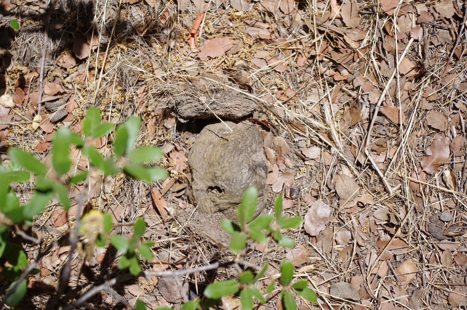
It was June 30th 2014, my wife and I were returning back to El Cajon after staying at my brother's place in Ranchita, California for a few days. We stopped in Julian for a chocolate malted milk shake, then pushed on south to see what Cuyamaca State Park looked like now. This photo above is the desert view turnoff on Hwy 79 south of Julian called "Inspiration Point. Years ago someone planted Cuyamaca Cypress all around the parking area and median island. They spread out into the chaparral in the old days before fire swept through here. I recall finding seedlings everywhere in the 1970s. I know, it's faith shaking shocker when a much worshiped doctrine gets blown out of the Fire Ecology water, but life is like that. There were some small narrow unmarked trails where persons who visited have created through the chaparral so I followed a few, but something curious caught my eye as I veered off trail an in between Manzanita and Scrub Oak I found what for me is the glittering of gold, a mother load of sorts. Stone-like truffles of Pisolithus tinctorius. 

photo Mine Inspiration Point Hwy 79 south of Julian
The above image has been manicured a bit so that viewers get the full flavour of what they actually look like. Here I have pulled back some of the dry grasses, leaves, dirt and other debris for the camera. To most people hiking in the outdoors, they look rather like small stones. But I've always got my nose to the ground every time I go out, just a habit I guess.
Photo Mine: Now on my FB page
Here is the same image of the above truffle with another I've cut or broken in half to reveal what's inside of these gems. Unlike normal puffballs most folks might be familiar with which explode in a cloud of dust when opened, these have a compartmentalized interior. Mocha brown inside and gives off the scent of caramelized sugar of English Toffee in my opinion. Often referred to as the Dog Turd Truffle, it is a main pioneer fungi for most all ectomycorrhizal plants which are just getting started. Below here is a picture of a truffle which I have not removed the debris around. You can understand why most people wouldn't notice such a gem.
Image Mine
But now look below here, they do come much bigger

Image Mine
Two images of the same truffle above and below here. The lower one allows you to view the American Quarter coin much more clearly which I used for scale. Almost the same size of a Swedish Kronor. I've seen these things get much bigger before, often on my own property in Anza in the past. Once on the backside of Palomar Mountain in 1983, a friend of mine and I went up the forestry road behind Aguanga off Hwy 79 and up near the top in a previous years wildfire burns and after the monsoon Thunderstorms had dumped rain over the last several weeks, we saw large white Puffballs larger than the size of a Basket Ball all over the blacken landscape with which it contrasted beautifully. I really wished back then I had thought to carry a camera.

Image Mine
~~~~~~~~~~~~~~~~~~~~~~~~~~~~~~~~
Other things discovered at "Inspiration Point"
Image Mine
Okay now time to pay attention here for a moment. This is looking south from the "Inspiration Point" area and the hill where some trees are recovering from the 2003 Cedar Fire which took this place out almost completely. I still have nightmares of watching Ed Lenderman of KUSI over dramatizing the high winds at this spot live. As you can see there are some pines trees and even Cuyamaca Cypress growing back. Although for a recovery that is eleven years in restoration, it's clear that even rain here has not been in great abundance. Okay anyway, is there any colour that stands out place and jumps out at you in this photograph ? I'll give you some hints, it's not any shade of green, nor sky blue. It also has nothing to do with the reddish brown soil at the bottom foreground of the picture.

The chaparral here at "Inspiration Point" was the healthiest and most beautiful in all of San Diego County, something I had not seen anywhere, but a few places like Palo Colorado Canyon up in Big Sur California off of the Cabrillo Hwy 1. Okay, to the right here is a Humbolt Lily which was growing up out from a medium sized California Coffeeberry Shrub. Not what most people would consider ideal gardening conditions for any kind of Lily. But that's the native chaparral ecology. Fungi makes many things work when all pistons are firing properly. I have some more pics and more stories of things I did here. Like planting Native Plants in hot weather, inoculation and watering properly under harsh conditions. Some natives can be watered and others not. Inoculation is always a must if you want to succeed in the urban landscape or garden. However, unless things weather and climate-wise change radically, I do not believe any remote wildland area restoration will succeed, even if you inoculate with a great mycorrhizal blend. You need rain, not necessarily heavy rains, but back to normal rains will work. There is so much going wrong in the outback environment. To much to ponder. Get outdoors and discover how different Nature is from what the textbooks insist is truth. You'll be amazed.


Thursday, July 24, 2014

Anza Expedition Summary (also places, people and things of interest in SJ Valley)

Bautista Canyon, San Jacinto Valley & Mystic Lake


A couple of real quick links from my first two Main posts as mere reminders and then to my final post:
(Part 1) Juan Bautista de Anza's Journal sheds light on a past Extinct Ecosystem
(Anza Expedition Part II) The Valley that was, but isn't any longer
~~~~~~~~~~~~~~~~~~~~~~~~~~~~~~~~
Map image:  Juan Bautista de Anza National Historic Trail Guide

This was to be my final and last post on the Anza Expedition which for me the story closes at the Santa Ana Riverside at Mount Rubidoux. But I've had to break it down into smaller sub-subjects as there was just too much to consider and the side points were pertinent to the overall picture of the expedition. That's the curse of knowing the area so well and I still have told the half of it. Beyond the point where Anza comes to the Santa Ana River at Mount Rubidoux in Riverside California, I really have vague knowledge of the natural world beyond that point which has mostly been swallowed up by human development. So I'll merely offer some recap here and add some interesting facts about San Jacinto Valley's history, places and people I've enjoyed meeting down there in my own historical past. So again, some recap of what I've already written about.

Once you enter onto the valley floor from Bautista Canyon's mouth, the area prior to agricultural development would have been more like a Bajada or Alluvial fan. It's interesting that ONLY Fray Pedro Font made mention of the Bautista Creek splitting into separate and distinct two river channels as it emerged from the mouth of Bautista Canyon where he described the waters eventually disappearing into the sand a ways down stream. This to me would indicate that the first trip took the more historical westerly route of the stream and the year after they took the Bautista Wash route more to the north where this water seemed to disappear under the sand and gravel. That would make sense if it were a newer stream which for unknown natural causes was created by flood water debris creating a diversion and siphoning off some of the water from the main original historical channel. Therefore the second Trek's camp would be on the eastern side of Park Hill.
"After about four leagues the canyon becomes wider and the water of the arroyo, which at the end divides into two branches to open out into the Valley of San Joseph [San Jacinto Valley], is lost in the sand."
The present Bautista Creek from the Flood Control Dam is a very deep concrete flood channel which has been routed north towards the San Jacinto River channel. This channel no doubt most likely followed a more westerly pathway in the old channel with meanders northwest on just the east side of Park Hill. The second channel may have even made a more direct western route along present day Stetson Ave on the south side of Hemet. What ever the situation in the past, the present man made concrete channel was likely created to allow the many human agricultural endeavors for the exploitation of the landscape for various Orchard enterprises which are mostly gone now. In any event, I wrote about this here:
Old Bautista Creek Channel East and West side
~~~~~~~~~~~~~~~~~~~~~~~~~~~~~~~~
Image: Jay Beiler

Cahuilla Reservation looking north at Mount Jacinto
and Cahuilla Mountain on the left hand side.
It is also extremely interesting to take special note that the elevation gradient from Hemet to the town of Winchester and points west like Menifee and Sun City is only a mere inch or more. At least this is how it was explained to me by one of the city maintenance people. In any event, this valley has always had drainage issues. Not that this is a bad thing in a wildlife natural world sense, but for human infrastructure and commercial pursuits it's always been a problem. It can and will flood instantly even during a localized heavy summer monsoon thunderstorm event in July/August. This is important for everyone to understand the personal observation written down by the Spanish eye witnesses a few hundred years ago. Because from the very point at which they emerged from the mouth of Bautista Canyon, the first thing that impressed all journal writers was the heavy abundance of wildflowers everywhere just as they had experienced up in Anza valley when traveling through what is now Cahuilla Indian Reservation. Hemet Valley itself was often most likely one large continuous massive vernal pool from it's central and western edge all the way to Winchester and perhaps beyond. I actually found an image below which in an impressive illustrative way depicts almost identically the geography of flat valleys accompanied by pyramid shaped hills or saddle back boulder strewn small hills of this San Jacinto - Hemet Valley region. Notice the landscape in this picture below with slow moving flood meandering water courses which branch off into numerous landscape tributaries to create Vernal Pools ?


Golconda, NV / Humboldt River at flood stage on 6/9/2005
This is my second deviation from this main post. The reason I am veering off track here is to illustrate the beauty that both Juan Bautista de Anza, Francisco GarcĆØs and Fray Pedro Font all expressed about the massive wildflowers displays which seemed to deeply touch their hearts. Most people who have seen such display of wildflowers even on small scales can of course relate. Sadly most of this is gone forever as development has encroached and continues to do so. Please follow this link for a deeper picture of the reality of wildflower strewn Vernal Pool wetlands: 
The Vernal Pools of South and Western Hemet (Anza Expedition extra) 
~~~~~~~~~~~~~~~~~~~~~~~~~~~~~~~ 
Okay, I am veering off here again to create a separate post which can be more detailed in proving just what these men actually saw of the what, why and how of it's existence. Please follow this link for a deeper appreciation of the geography of the valley and other water feature tributaries which will make that long gone historical massive riparian ecosystem a reality for you that Anza, Font, GarcĆØs and others on the expedition wrote so highly and praiseworthy about. Also take note of the comparison Anza finally makes of the Santa Ana River looking exactly like the San Jacinto River Valley. That reality back then no longer exists:
The San Jacinto River Valley that Juan Bautista de Anza saw 
~~~~~~~~~~~~~~~~~~~~~~~~~~~~~~ 
Here is an entirely different post written strictly about the present San Jacinto Wildlife Refuge and what is left of the wetlands they described. I'll also follow the river bed down to Elsinore and through Temescal Canyon, something the explorer's did not do. The main purpose in my veering off course here and following the riparian system which these men did not follow have more to do with wildlife & ecosystem purposes only. The possibilities of Southern California's Steelhead Trout actually living and existing in the upper reaches of the San Jacinto River habitat and evidence for the California Grizzly Bear presence in the area as mentioned by one of the members of the Expedition:
San Jacinto River Wildlife Refuge & the wetlands potential beyond to Corona 
~~~~~~~~~~~~~~~~~~~~~~~~~~~~~~ 
Finally as with anything I write, I'm interested in lessons learned and if there are anything we can come away with as far as practical applications to be used in habitat restoration, urban landscape or just your small garden.  
Anza's Dairy & the Lessons Learned
~~~~~~~~~~~~~~~~~~~~~~~~~~~~~~~~~
Fast Forwarding to the present with places and people I enjoy
Address: 1977 S Hewitt, San Jacinto Ca
Tel: (951) 658 2426
This past June 2014, my wife and I stopped in the San Jacinto/Hemet valley on our way to visit and stay with friends in Phelan California. I decided to revisit some of my most favourite places and the people who live and work there. First stop was the Savala Fruit Market located north of Park Hill on S. Hewitt. When I lived in western Riverside County back in the 80s & 90s, I often stopped here specifically for their Apricots. Hemet valley was a one time a major Apricot producer in times past and in fact when I first moved to Idyllwild, eastern Hemet Valley to Valle Vista still had many major Apricot Orchards. It was sad to see them plowed up and the land used for housing. Savala Ranch is the last hold out and shrinking fast. Their ranch of course is smack in the middle of development country. C&R Farms [the largest grower of Watermelons, Pumpkins, Squashes and Gourds in the Valley] had a large field of watermelons on the west side of the Savala Ranch when we visited.


Savala Ranch Fruit Stand, San Jacinto California
Fernado and Ofelia Savala started the 16 acre Apricot Orchard and Fruit Stand I believe some time back in the 1960s. Fernando came from Mexico in 1940 as an Apricot picker and later enlisted in the Army during World War II, and during this time married his wife Ofelia. Their son now runs the Ranch and told me his father has since died and mother only comes out occasionally when she has the energy. The northern end of the Farm has had it's beautiful Apricot Orchard removed as the water is now scarce and expensive. They can no longer flood irrigate as in times past and use only drip irrigation under the trees on the south side of the Apricot Farm on Hewitt. It makes me sad, as the apricots were far smaller than in times past when they flood irrigated. The trees themselves are of the older larger standard antique variety, which means more potential for deeper root infrastructure if it gets trained properly. I almost wish I could spend a year there and help them turn things around with what I know and understand about deep pipe irrigation (Article Here) . I'm sure the water rates from the municipal water company are outrageous. One wonders how long they will be able to hold out. 

photo Mine


photo Mine
The apricots were very very small by comparison to the old days. In the old days they sold them fresh, but also dried the majority out in the sun behind the sheds. As anyone knows, apricots do not have much of a shelf life and drying is preferable for many. Below here is a picture of some old wood built Ice cooled Boxcars which were later replaced by the common refrigerated unit cars like those of the Pacific Fruit Express cars seen for years. The Savala Ranch has the same two, but at one time these boxcars could be seen everywhere on all the valley farms which were bought up cheap by farmers for storage sheds.

image Mine: old block ice cooled fruit boxcars
The photo below is not mine, but apparently from a Savala Family member's photobucket collection. The uncanny thing here is the photo of the grandmother Ofelia is exactly the way I remember her, as opposed to present. The other uncanny thing is that long extended baby blue Ford Econoline Van looks exactly like mine when I stopped by during the middle 1990s and picked up produce for resale. This was the same Van I used in distributing bread for Dudley's Bakery out of Santa Ysabel. Hmmm, maybe Fernando Jr can help me out here, any idea of the date this was taken ? BTW, it should be noted that the Savala Family has always tried to practice organic farming. Here is their Facebook page: 
https://www.facebook.com/SavalaRanch

Image Lady Daniela

Savala Ranch Photos
~~~~~~~~~~~~~~~~~~~~~~~~~~~~~~~~
image Mine
Little Pantry Cafe (formerly Hamby's Cafe)


Address
  • 980 N State St
  • Hemet, California 92543
Phone
+1 951-929-0908
This location and cafe was originally called Hamby's Cafe. It is now called "Little Pantry Cafe" and has much the same character and atmosphere as before. My favourite food here was breakfast (which they served all day), but sometimes I stopped in the evening for dinner when I drove home from work on my way to Idyllwild where I moved in 1981. What can I say, I was single back then and had money for eating out a lot. I was first introduced to Hamby's by Marvin Lindholm, who now lives in Lake Arrowhead, California. I use to order Hamby's "Lumber Jack Breakfast" which by name causes you to imagine a breakfast fit for only a Paul Bunyan. True to the name, one could rarely finish it. As a side point to my article on the Anza Expedition, just a few meters north of this cafe on State Street, the geography slopes down sharply revealing the old San Jacinto Flood plain and ancient river valley, though I highly doubt any resident or traveler ever gives it any mind. You can actually follow the entire floodplain edge if you know where to look when driving both east and west. The line is very distinct and obvious. Still, from that vantage point one could stand here and imagine the lush scenery Anza, Font, GarcĆØs and others witnessed as the area's first European explorers.

image Mine
This place is basically the same, with the exception of the name and owner. In the above photo, you'll notice the entrance into a larger room. In the early days the Cafe stopped there at the wall. Hamby's owner later remodeled and made the place much larger. Most regulars in the old days would stand in line waiting to get in, morning or night. My wife and I definitely enjoyed the breakfast we had and it was almost identical as I remembered it. It's the kind of food you can tell is made from scratch like all older Cafes of days gone by. The taste test is whether the gravy in their "biscuits n' gravy" taste like wall paper paste or loaded pan drippings from the bacon and sausage. *smile*
~~~~~~~~~~~~~~~~~~~~~~~~~~~~~~~~
 Bats put on a nightly show from under the Bautista Flood Channel bridge at Fairview  in Valle Vista south of  Hwy 74 (Florida Ave)

Image: Press Enterprise - Bat Colony under Bautista Creek Flood Channel bridge - Valle Vista
 Admittedly, Hemet and San Jacinto have never been on most outsider's list of places to go and things to see, but there are some refreshing off the beaten track things to experience if you've got the time. Here is the article link below: 
http://blog.pe.com/news/2012/09/12/can-valle-vista-bats-save-hemet/ 
Here is the updated article on the Bats of Valle Vista in what is known as the Fairview Bat Bridge in Hemet California by Bob Pratte of Press Enterprise on June 24, 2014: 
by Bob Pratte: VALLE VISTA: Sundown show at The Bat Bridge 
~~~~~~~~~~~~~~~~~~~~~~~~~~~~~~~~
(951) 845-1217
38021 US Highway 60
BeaumontCA 92223-1680
Our last stop on the way to Phelan was this well known tourist spot called Dowling Fruit Orchards at the interchange of Hwy 60 & Interstate 10. This was actually one of my customers when I distributed gourmet bread & some produce to western Riverside county clients like Hadleys, Tom's Farms and Rancho Fruit Market in Temecula. The Fruit Stand was only a small part of the larger fruit orchards which once existed to the east and south of the stand which is right on Hwy 60. All manner of tourist, locals and large number of Truckers stop here. It's owned and run by John Dowling who I did run into and had fun catching up on what's been going on in both our lives. I was happy to see his dad was still alive, but of course I already knew his mum had died. But it's very much like the other tourist places referenced above but with more of a Mom n' Pop flavour about it. Below I've got some other reading references about the history of San Jacinto Valley.
~~~~~~~~~~~~~~~~~~~~~~~~~~~~~~~~ 
I also remember the account about the scene named "Massacre Canyon" which is actually Portreo Creek just north of Gilman Springs Rd. Two tribes of Native Americans [Soboba & Pechenga] had a bloody battle here up this canyon. I've heard two accounts, but the main one is about the Chia Seed version. I'll post below here my article on lessons learned about Bajadas or Alluvial Floodplains, where I reference the early 1980s El Nino event flooding which created a lush dense triangular shaped riparian forest from out of the mouth of this canyon all the way to the San Jacinto River. Only a medium percentage of this large sized remnant of those trees exist to this day. This is one of the main tributaries Fray Pedro Font wrote about which he insisted helped fill and maintain Mystic Lake to the west.
Massacre Canyon: The Chia Seed version
Lessons Learned from the Bajada (Alluvial Fans)
 Also, don't forget the USGS Historical Topographic Map Explorer, which I just clicked on an old 1904 Southern California Topographical Survey map. It listed Eden Hot Springs which I had forgotten about halfway between Hwy 79 (Lamb's Canyon) and the old original hwy out of SJ Valley, Jack Rabbit Trail. The older map also shows the long gone railway spur from Perris ending at Lakeview, most folks never have known about this spur. It was mostly a real estate scheme for selling land. You'll understand the name if you've ever taken the trek between Gilman Springs Rd and Hey 60. It is paved, but older pavement and very twisting winding narrow roadway. All along the drop offs along the Canyon edges is the old original wooden guard rail and some Route 66 era steel type guard railing. In Anza, Cahuilla Reservation is spelled Coahulia. Just some interesting side points. well worth bookmarking. enjoy.
http://historicalmaps.arcgis.com/usgs/ 
~~~~~~~~~~~~~~~~~~~~~~~~~~~~~~~~
image by Tom Grubbe (2011)

Looking south towards Mystic Lake and San Jacinto Wildlife Refuge with the community of Lakeview in the far distance long Jack Rabbit Trail.

Wednesday, July 23, 2014

Emissions from forests influence very first stage of cloud formation

Hopefully everyone here has taken their Ascension Island Syndrome vaccination shots ?
"Clouds are the largest source of uncertainty in present climate models. Much of the uncertainty surrounding clouds' effect on climate stems from the complexity of cloud formation. New research sheds light on new particle formation -- the very first step of cloud formation. The findings closely match observations in the atmosphere and can help make climate prediction models more accurate."
(source) 
Credit: © Dmitry Parvanyan / Fotolia

And the winner is ? Yes, forests and of course other old growth plant community groups. To bad many of these ecosystems have been declining as of late and are most notably never mentioned nor referenced as having major impact on climate change as a result of their absence. Historically, their absence has brought on drought and higher temperature ranges on average around many parts of the globe even when the scenario was localized. As I've written in this blog [which is mostly about how nature networks & cooperates] previously, more goes on in ecosystem function than mere fungi interconnecting differing types of vegetation, sharing water and exchanging various chemicals for the well being and survival of everyone and everything in that community. Our general global climate systems as well as localized weather phenomena are tied to these varying plant mechanisms. But as the article states, these systems are just the beginning of cloud formation. Finally more and more of NASA's Satellite intelligence imagery is picking up on the reality of what many have been pointing out for years, Earth's vegetation clearly is the first line of cloud formation and weather creation. This understanding of course was lost recently at the end of last year 2013 when freelance author Fred Pearce wrote about the amazing turn around of a once desert island into a tropical cloud forest. Evidently there is little if any interest by many in the scientific world for studying this amazing turn around, and understanding the natural mechanisms involved for which practical application just might halt & perhaps reverse Earth's global climatic disruption. Now why is that ? Because the official global Scientific Orthodoxy's view is that the cloud forest's mere existence is artificial and unnatural. In other words it didn't evolve naturally as it should have. Excuse me ?  Almost immediately every single religiously driven ideologue came out of the woodwork condemning Fred Pearce for his article calling for study of and practical application being done elsewhere. Do a serious Google on some of the folks in the comments section at the bottom of that article who were involved in demonizing Fred Pearce. You'll find many of them spend more time in political and ideological squabbling in attempts to highjack world power than they do with anything regarding science. Science apparently is nothing more than a dastardly cloak for something more insidious. Does anyone see why the present ongoing Climate Change disaster [which I know for a fact is happening] isn't being taken more seriously than it should be by the average person ? Now let's take a close look at what this latest NASA photo reveals below regarding vegetation and cloud formation.
 
(NASA image courtesy Jeff Schmaltz, MODIS Rapid Response at NASA GSFC )

 "These clouds are almost certainly a result of evapotranspiration. The clouds are distributed evenly across the forest, but no clouds formed over the Amazon River and its floodplain, where there is no tall canopy of trees. While water may evaporate from the Amazon River itself, the air near the ground is too warm for clouds to form. Trees, on the other hand, release water vapor at higher levels of the atmosphere, so the water vapor more quickly reaches an altitude where the air is cool enough for clouds to form. When water vapor condenses, it releases heat into the atmosphere."
~~~~~~~~~~~~~~~~~~~~~~~~~~~~~~~~
Photograph courtesy NASA/Goddard Space Flight Center Scientific Visualization Studio
The border between Haiti (left) and the Dominican Republic highlights the relative deforestation of Haiti. Take note of the slight formation of clouds over the vegetative regions left intact. Subtle, but still there.
 Satellite Photos Reveal Desertification & Cloud Formation Anomalies
Previously, I've written a post back on February 6th 2013, using the above photograph of just such a cloud formation phenomena as observed from NASA Satellite photograph which was actually intended to illustrate the contrast between the still forested land of the Dominican Republic and the deforested land of Haiti. I'm actually surprised that it actually generated almost 600 reads or views. But all of the journals highlighting that photograph all missed something very important. Although it's not as spectacular as the above photo of the Paria River area of the Amazon near the top of this post, the evidence is nevertheless still present although subtle. Back in the late 1970s and 1980s, I never needed such NASA Satellite proof to tell or prove to me what I already knew and could observe from the ground up in Anza California. Back then it wasn't hard to do. Many old growth Chaparral/Oak Woodlands still existed back then and the cloud formation during the monsoon season was easier to observe over certain specific geographical locations which contained the deepest old growth Chaparral. This phenomena persisted year after year, only being disrupted when fire came through obliterating the locality. Such formation also was not necessarily limited to geological Orographic mountain top areas where uplift would & should be expected. Many of these heavily vegetated regions up in Anza were nothing more than rolling foothills far away from any higher mountain peaks where it would normally be assumed such formations would usually occur. The idea of course is that the warmer moister air moving upwards would condense into clouds as it met the cooler air at the higher elevations. While this can be a factor, it was still not necessary as such conditions of cloud formation can and do happen even over desert areas. It was also a fact that often times very little wind was associated during this formation, other than a slight gentle breeze. As the article above pointed out, this phenomena is mainly being associated with the aerosols being given off by the vegetation which provide the necessary particle nuclei for the water droplet creation. The chaparral plant community has very intense noticeable VOCs they give off during monsoonal events.

The sad thing here is that only forest areas with trees will ever be discussed, dismissing any reference to the importance of Chaparral and other plant communities like even those of desert ecosystems. As I've previously written about, Desert plants of the southwestern USA have also been observed to give off aerosols which react with the air to create a mere haze which acts as a sort of natural sunscreen when temps reach a high point and trigger a mechanical response withing the plant life's genetic mechanisms. Again, none of this will ever see the light of day in any of the Global Warming or Climate Change debates where nothing more than spitting or poop throwing contests by the usual ideologues are more preferred than actually reaching people's hearts to see the dire need of great & radical change in human behavior. Below is a paragraph from the Ascension Island's own conservation website which describes it's own forested mountains this way in surprising and negative terms. 
"Prior to human settlement, the native ecosystems present on Ascension were almost certainly at a relatively early stage of development, making them particularly susceptible to invasion by introduced plants. With the first human inhabitants also came the destruction of large areas of native habitats and large scale re-planting e.g. with trees/ shrubs that provided a source of wood. Perhaps the most significant event in the process of transformation was brought about by the eminent botanist Joseph Dalton Hooker. He implemented the mass planting of organised forests, shrublands and pastures on Ascension, introducing over 220 exotic plant species from diverse parts of the world, with the aim of greatly increasing mist interception, soil development, water storage capacity and of reducing erosion. Today, Green Mountain is largely covered with dense invasive vegetation and man-made cloud forest." 
"Even the lowland areas of Ascension have now been substantially invaded by non-native shrublands – guava (Psidium guajava) became widespread in the south-east of the island during the early 1800s, Mexican thorn (Prosopis juliflora) has spread rapidly since the 1970s and yellowboy (Tecoma stans) even more recently than this. Introduced species now comprise approximately 90% of the higher plant flora." 
http://www.ascension-island.gov.ac/government/conservation/our-species/endemic-plants/
~~~~~~~~~~~~~~~~~~~~~~~~~~~~~~~~
 - March 2013

The Administrator officially opening the new Elliotts Pass educational nature walk
The website then offers this critique under a picture of the tree vegetation and concludes with: "Artificial cloud forest on Green Mountain: a direct legacy of Hooker’s experiment"
image: Daily Mail
The Ascension Island website insists on utilizing the term "Artificial Cloud Forest". This is inaccurate because what exists is a true cloud forest which incorporate actual living biological components which manufacture and create the island's present day climate and rainfall. The idea of a cloud forest is to include the understanding of such a system's ability at tapping into moisture streams off oceans,  the creation of cloud formation, hence thereafter rainfall. So it's a true cloud forest in the natural sense. The image above of Meteo System's [Weather Modification Company from Switzerland] animated example of artificially creating rain over Dubai and other parts of the Arabian Penninsula is my idea of an artificial system. Natural systems are becoming far less and will most likely be out numbered in many areas around the globe as time goes on, by all these science-based artificial weather modification systems. So my preference for weather modification is a more natural one which was proposed by Botanist Joseph Dalton Hooker and illustrated by the reality that exists now on Ascension Island. Yet many of these Conservation Fundamentalists and the British government apparently would like to remove it under the guise of saving endemic plants. Seriously, the Fundies come in all flavours.

Here's another Fundie doctrine. It's the continued ongoing worship, romanticizing and praise of Native Americans using Fire to destroy supposedly dense forest vegetation and create more grasslands and meadows for big game animals like Deer to graze and feed upon. So let me get this right, Native burning and destroying forest vegetation equates to something natural, but Botanist Joseph Hooker and others planting trees on barren volcanic mountain constitutes an Artificial Cloud Forest ? Had the original Ascension Island pioneers brought over Native Americans as slave labor and made them plant the various types of exotic vegetation, would it then be considered a natural cloud forest as opposed to an artificial one because the native North American Tribes caused it to be so ? Are Native Americans to be considered nothing more than animals who were merely part of the ancient ecosystems ? What is it exactly that makes Europeans human by comparison ? I don't mean for these to be dumb questions, but many of the absurd positions taken by experts and the asinine assumptions and assertions found in many of the scientific publications lead one to believe that's what and how they think. Here is what I wrote much earlier on land mismanagement and differing opinions by different land stewards on the subject:
Forest Ecology & Management: Will Researchers ever get on the same page ?


NASA photo near Dolan Springs Arizona, Lake Mead & Grand Canyon

Above is my newest favourite picture on this subject of cloud formation over specific vegetated areas. The contrast is clear. This area is north of Dolan Springs Arizona, with Lake Mead to the left, Grand Canyon through the middle and a patchy vegetative landscape with small cloud cover overhead, indicating perhaps the beginning of the summer monsoon season kicking off. I love the natural cloud forming mechanism which can easily be observed and studied, but it's the destruction of important forested areas which can radically change the local and regional landscapes and perhaps climate in some cases forever. Many regions of the planet, this could be irreversible. Not one viable major vegetation rehabilitation program do you ever hear about as a viable climate change solution. It's all about Big Temps and CO2s. Evil Corporations and the supposed politicking behind them. Let's be honest here, no one political ideology is responsible for the destruction or going to bed with corporate interests. They all do it. Any political entity that champions eco-green over National economy loses big time. They all have to play the economy game. But once again, nobody in the public ever gets a thorough enough education on what creates and actually drives climate out there in Nature. As long as they use the same failed script they've been ordered to use in discussing climate change, don't expect the public to ever listen.


Photo by Brock Whittaker (Virga Clouds over Arizona Desert)
Proverbs 25:14    
14 "One who doesn’t give the gift he promised is like a cloud blowing over a desert without dropping any rain."

Ever experience a day in the middle of the summer hot sticky humid monsoonal season, where the clouds build up in the morning, seemingly providing a promise of relief later on in the afternoon, only to disappoint ? Those clouds are known as Virga Clouds. Virga is an observable rainy streak or shaft of precipitation that falls from a Thunder Cloud but evaporates before reaching the ground. These are dry Thunderstorms. They only offer a little shade from the intense hot summer sun. Something called dew point near the ground where there is very low humidity and high temperatures that can cause the rain to evaporate completely  in midair before your very eyes, shortly after its released from the thunder cloud. Desert areas often have clouds showing Virga Clouds, but they are also occurring in the mountains more frequently. In fact, the precipitation often starts out in the form of ice crystals and never reaches the ground. Hence the proverbs comparison of someone who promises but has no intention of delivering on the promise is like a Virga Cloud. Our planet's present leadership is almost the mirror image of the Virga Cloud phenomena. Folks need to reconsider what and who they are putting their complete trust without question in these days. Expect the forced change to not be pleasant. 
Those Conservation critics & indeed many of the Climate Change champions who down played the successes at Ascension Island are setting themselves up for a big fall. I'd like to think that these biologists and other ecologists will learn a lesson not to hasten to disparage an ecosystem success story and those who make noble attempts at rebuilding Earth's Forested climate mechanisms, calling their work artificial and unnatural, let alone mocking someone like Fred Pearce the way Kieran Suckling did so crudely in the comments section at the bottom of the ascension Island  article. Unfortunately, so-called higher scientific criticism like this often does years of damage on impressionable younger minds who are looking on and just starting to learn how our natural world really works before these criticisms are eventually debunked as the science envy & jealousy they truly are. One has to ask at this point, though, how many other great biomimetic inspired “eco-solutions” of climate change ideas are waiting for their turn at the intellectual guillotine of “superior knowledge”?  Don’t be so gullible as to believe that the present Climate Change leadership gang who claim all there is that is knowledge position is conclusive. This is been brought to you in the tradition of radio icon Paul Harvey’s famous pivotal phrase, “And now, the rest of the story.”
~~~~~~~~~~~~~~~~~~~~~~~~~~~~~~~ 
Further Reading Interest
http://www.ascension-island.gov.ac/government/conservation/our-species/endemic-plants/
Earth's Internet: "Climate Change & Ascension Island
Forest Ecology & Management: Will Researchers ever get on the same page ?
Wow, So Trees Cause Cloud Formation and Create Climate ?
Old Growth Tree Roots are far far more than Nature's Climate Thermostat
Tropical Storms Linger Longer Over Wet Land & Fizzle Over Dry, But in Truth it's a Universal Phenomena Globally Speaking
Dances With Myths: Indigenous Native Peoples and Fire Ecology
How much Reverse Engineering of Earth happens before Humans Admit there's a Problem ?