Palo Colorado Canyon Rd, Big Sur CaliforniaNow further inland from the coast on the eastern side of the Santa Lucia mountain coastal chain & Hwy 101 from Salinas south to Paso Robles over to the San Joaquin Valley it did indeed deserve the label "Exceptional" Drought. The steep hills which should be chaparral covered have been grazed to the bare soil for more than 100+ years. Only a handful of rare pockets of chaparral and Oak/Pine woodland are present. The closest exact location of a photo I can find which matches the area we past through and the landmarks we witnessed in exceptional drought is from a Google Earth - Panoramio user, 'Patmon' who photographed an exact spot we drove through this past June 2014, only the date was in 2009. I was tough with myself not to take too many negative photos, but maybe I should have taken a few for educational purposes. The photo below is a bit deceiving if you drive through this area on Hwy 58 today. This picture is actually a lush grassland compared to the reality of what my wife and I experienced on the drive all the way from San Joaquin Valley town of Buttonwillow to Santa Margarita near Hwy 101. There literally is no grass at all at this very moment of writing. The entire landscape is nothing more than bare soil with not even a whisper of any stubble. Joel Salatin was right, the rule of grazing on hilly terrain should be, "If you cannot drive a tractor on it, don't graze cattle there." The only exception of the presence of plant life of course were the pockets vegetation high up the ridges like chaparral and mature oak trees which you can see in the photo below and there were not many of those vegetation pocket islands to be found.
 |
| Hwy 58 Buttonwillow to Santa Margarita California |
 |
| image Mine: Along Cabrillo Highway at Big Sur California |

As we all know, things regarding climate and generally local weather in most areas have been trending poorly. Like the historical tracking chart above of San Diego for a last two decades which while showing a couple spikes above average, these still don't make up for the well below normal dry averages which are more common in recent years [especially the past decade]. Last Winter I actually followed the weather rain events and storm totals throughout Southern California. What I remember most is the lack of consistent rainfall amounts across the entire southland. Some areas were drenched while others got only a mere trace. San Diego which is supposed to average around 10.34 actually received only 5.05 this past season and that following two previous dry years which have progressively gotten worse - 2012 @ 7.09 & 2013 @ 6.55. There is one particular rainfall record I also followed, though it's unofficial, it matches identically those of the official reporting stations throughout California. The record is on a blog called "Breathing Treatment" and written by Brent Morgan who lives in Rancho Palos Verdes along the coast in Los Angeles County. The way he went about reporting was by storm/Date, not monthly totals. I think this illustrates beautifully just how the total rainfall here recorded actually becomes worse when you consider where it went or rather where it didn't go.
Brent Morgan recorded the 2013/2014 rainy season by Storm Event with Date - Month/Year
October 27, 2013 - 0.15
November 20, 2013 - 0.54
November 29, 2013 - 0.4
December 7, 2013 - 0.27
January 29, 2014 - 0.001
February 2, 2014 - 0.19
February 6, 2014 - 0.28
February 7, 2014 - 0.02
February 26, 2014 - 0.83
February 27, 2014 - 1.5
March 1, 2014 - 1.0
March 25, 2014 - 0.02
August 2, 2014 - 0.09
Total Storms 13 - total rainfall for season 5.29 inches
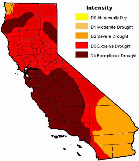
(Rainfall Totals Source)Now what is interesting to me with Brent's Rainfall Record and more importantly it's not so much the total rainfall amount at the end of season, but the low storm event amounts and significant time lapse between the storm events. There is almost no real measurable percolation into the soil, with the exception of maybe a little over three inches between February 26th through March 1st. No beneficial moisture even came close to penetrating the subsoil to sustain any newer season plant growth, which explains why many shrubs refrained from putting on any new growth this season [my firsthand observation] with the shedding of more leaves as a result of drought stress and the fact that even weeds and other annual grasses made very little if any showing in many areas this year. This was even worse up north of here in Monterey and San Luis Obispo Counties which are at the center of the "Exceptional Drought" Zone. Now factor in the present drought over the past three years which has actually halved most of those same California annual average totals in almost every location throughout the State, which would bring numbers way down further, this still is a puzzle as to what exactly is sustaining not only the good stream flows along those central coastal areas, but what must also be sustaining the massive usage necessary to maintain the large volume of old growth forest for this region. So what gives ?
"Hydraulic Redistribution", but especially & more specifically "Hydraulic Descent"
 |
| image mine: Big Sur coastline with fog and low clouds rolling inland |


"From 25 to 40 percent of the moisture in the system comes from fog," says Todd Dawson, who has been studying the relationship between the coastal fog and the redwoods for two decades. Some of the fog simply covers the leaves and prevents evaporation. But some of it also enters the stomata, or tiny pores, on the leaves and is drawn down through the branches to the roots. This is the reverse of transpiration, the normal flow of water from the roots to the leaves that exists in most trees. Redwoods are the first trees found to move water in both directions, though others have been identified.
Fog is not just a vital element for the redwoods—it's also crucial to the entire redwood forest ecosystem. Some of the moisture drips off the redwood leaves, landing on the forest floor to water the trees and young saplings. "It's not just a drip, drip, drip," says ecologist Holly Ewing of Bates College in Lewiston, Maine, who also worked with Dawson. "The moisture can descend into the ground up to 35 centimeters deep, and that's a lot of water."
Scientific American: "Clearing and Present Danger? Fog That Nourishes California Redwoods Is Declining"
~~~~~~~~~~~~~~~~~~~~~~~~~~~~~~~~~
Deep-rooted plants have much greater impact on climate than experts thought
UC Berkeley News - Press Release 2006 (selected paragraphs)
Trees, particularly those with deep roots, contribute to the Earth's climate much more than scientists thought, according to a new study by biologists and climatologists from the University of California, Berkeley.
The new study in the Amazonian forest shows that trees use water in a much more complex way: The tap roots transfer rainwater from the surface to reservoirs deep underground and redistribute water upwards after the rains to keep the top layers moist, thereby accentuating both carbon uptake and localized atmospheric cooling during dry periods.
Trees have long been known to lift water from the soil to great heights using a principle called hydraulic lift, with energy supplied by evaporation of water from leaf openings called stomata. Twenty years ago, however, some small plants were found to do more than lift water from the soil to the leaves - they also lifted deep water with their tap root and deposited it in shallow soil for use at a later time, and reversed the process during the rainy season to push water into storage deep underground. Dawson discovered in 1990 that trees do this, too, and to date, so-called hydraulic redistribution has been found in some 60 separate deeply rooted plant species.
During the wet season, these plants can store as much as 10 percent of the annual precipitation as deep as 13 meters (43 feet) underground, to be tapped during the dry months.
(Source)
~~~~~~~~~~~~~~~~~~~~~~~~~~~~~~~~
For Further information along these lines, I've actually created a resource page, so as not to over load the post here, which goes further into this amazing and fascinating phenomena which should be made simplified and inserted into every High School and College textbook around the globe:
How Forests Attract Rain: An Examination of a New Hypothesis called the "Biotic Pump"
~~~~~~~~~~~~~~~~~~~~~~~~~~~~~~~~After all this time I still don't know why the role of vegetation in our Earth's hydrological cycle has to remain so controversial and a mystery. Incredibly, around the globe, local indigenous peoples in many partially forested regions have always believed that forests attract rain, but climatology has until the last decade or so had no real scientific explanation for that belief. Of course many intellectuals will discount what many of these people say because they are often looked upon as illiterate and lack the Alphabet Soup credentials of those in charge of informing humankind just how the Earth functions. From the latest studies now, we know the roles these trees play in even simple cloud formation. Unfortunately, back in the Industrial Science News spotlight once again are Roger C. Bales and Michael Goulden adding their take to the controversy. You may remember that Roger Bales believes trees and chaparral are harming the Sierra Nevada Mountain's rivers and streams and therefore tree thinning by logging and salvage logging after wildfire should be championed to bring water flows [which he thinks trees & chaparral waste] to the San Joaquin Valley Industrial Agricultural business ventures. You may also remember Goulden along with Anne Kelly who slammed Jon Keeley & Dylan Schwilk for their take on why plants were moving up Santa Rosa Mountains above Palm Desert ? Anyway, they are pushing vegetation is evil hypothesis again, because they insist vegetation hogs water from rivers and streams needed to supply industrial farming interests in the valleys below. Therefore whether it's a "Burn Baby Burn" policy or removal by Salvage Logging by Timber Industry interests, Nature in the end is taking another beating besides the breakdown of it's own weather creation mechanisms which are no fault of it's own !!!
 |
| Credit: NSF Southern Sierra Critical Zone Observatory/Jenny Park Research at NSF's Southern Sierra CZO links snowmelt with downstream water supplies. |
"Trees growing higher on the slopes will soak up water before it can run into rivers" Roger C. Bales
"The paper's results should be "another call to improve forest management to protect the water system," Roger C. Bales
"Managers need to understand what's going to happen to the water runoff from the mountains," says Bales "This paper is another piece to help inform that and will hopefully get more people's attention."
National Geographic: "As California Warms, Greener Mountains Will Mean Less Water for People"
UPDATE: John Muir Project of Earth Island Institute is now pushing the Roger Bales Water Scam
https://www.facebook.com/JohnMuirProject/posts/3055613241179056
Berkeley Lab study finds California wildfires increase runoff, groundwaterYou have to also understand this business nonsense of cutting forests down to allow snow to reflect heat back into the atmosphere came out long before the John Muir Project pushing this narrative of wildfires are wonderful because they help water infiltration came out long before in 2013. The John Muir Project's, Chad Hanson, says he is against forest thinning or even clearcutting because it's bad for the environment, but a deveastating wildfire which nukes the landscape of all living biological things is supposedly a good thing because it facilitates water percolation and infiltration into the soil ??? Seriously ??? Really ??? Here's a 2013 Huffington Post article championing and waving Pom Poms for clearing the planet of forest trees because it's good for snow and cooling the planet.
Huffington Post: "Can Cutting Down Trees Actually Help Save The Planet?"
Here's my previous post on the Roger C. Bales Water Scam
Earth's Internet: "BREAKING NEWS: Apparently Trees don't really Gulp, Guzzle & Water Hog, only Humans do that"
Conclusions:I really don't want to get into Bales and Goulden's latest whining or even Chad Hanson's narrative of wildfire as the Grand Creator, but their worldview take on exactly how Nature actually works stands in stark contrast to what Todd Dawson/Inez Fung & Victor Gorshkov-Anastassia Makarieva have put together and published. And why are Gorschkov/Makarieva's research papers the ones that are given the label, "controversial" and not Bales' and Goulden's work ? Here's a better question, whose Funding backers stand to gain financially over such research work conclusions ? In any event, I'm banking on the later work of Dawson & Fung, Gorshkov & Makarieva for a more real world honest assessment. Do the hydraulic Redistribution abilities of Redwoods, Bigleaf Maples, California Bay and other native trees have the ability of sustaining stream flow within the coastal Santa Lucia Range ? So do I know for sure what is going on with consistent stream flow ? Not for a certainty, but I have a clear inference as to what the mechanisms could be. The fact that foliage transpiration is limited in such a marine coastal environment and that hydration mostly comes from marine layer moisture excesses rather than from roots to canopy, surely something far more important is secretly going on down below within this regional area marked by the U.S. Drought Monitor Authority as "Exceptional Drought Zone"
 |
| image Mine: Dense old growth forests in Palo Colorado Canyon Rd, Big Sur |
Dense Forest and Chaparral cover drying up of Streams and Rivers Theory just doesn't jive here in the Big Sur location of Central California
~~~~~~~~~~~~~~~~~~~~~~~~~~~~~~~~
Update: September 17, 2014
Remember the Pine Tree Health gauge ? The less there are past historical year's needles present, the more stressed and close to death a Pine tree is. Now judge for yourself the health of the largest tree in Idyllwild from the middle of the tree to the top of it's crown. So how much time do you believe this tree has left of life ? In the old days, you could never see the branching structure through the dense foliage. This is probably the last remnant of massive trees leftover from the early logging days when that Timber Industry stripped the Strawberry Valley of most of it's old growth which were as big as Redwood trees. For Jeffreys it was common for there to be 400 - 500 year old trees. The oldest on record I believe is a 631 year old Jeffrey in the Sierra Nevada ranges. Such old growth Ponderosa and Jeffrey pines will never come back again under the present system of mismanagement.

Wildlife Biologist Tom Robert's Forest Prophecy Fulfilled
 |
| Wildlife Biologist Tom Roberts |
The tree below here should not be a surprise to anyone. I wrote about this tree up in Idyllwild California which is actually growing on Taquitz Drive and right next to Strawberry Creek. The rooting infrastructure must be deeply entrenched within the Strawberry Valley's aquifer and yet this tree is clearly struggling here. The Mountain's ecosystem clearly doesn't have enough water to provide healthy it's hydration needs beyond the tree's middle trunk. Only a couple season's needles are clearly present, something that never existed a couple decades ago. Back in 1983, I went and visited Wildlife Biologist Thomas Robert's at his office where Town Crier Newspaper now resides. He had just published a report on the Ponderosa and Jeffrey Pines of Strawberry Valley and other surrounding communities around Idyllwild, in fact the Town Crier had carried his article in interview. He mentioned that most of the present trees, which were on average 90 years old at the time would all disappear in about 30-40 years and his recommendation was to replace them with Sequoia giganteum (Sierra Giant Sequoias) which were a tougher tree which would resist smog & drought much better. At the time it was a hard sell to believe in. Even though the trees all along Strawberry Creek were only 90 years old, they were so huge, large diameter trunks and vigorous foliage. The forest floor was so dark and nothing like the present openness it is today. I thought surely he must be wrong. Unfortunately he was dead on accurate. Most of those large trees are gone. Starwberry Creek in many parts are a stark naked contrast to their former glory. This seems to be the well extension global pattern everywhere. Humans are going to have to go after newer building and construction materials. Remember, 90% of the old growth Redwood is gone and the restoration plantations are incapable of providing the same service of weather mechanisms that old growth forests provide. This was also the information provided by the studies with regards the phenomena of "Biotic Pump" which I'll address at another time. Once again, look below at a powerful giant failing at life. The mechanisms which kept this beautiful majestic pine tree alive for 400+ years are no longer functional.
 |
| Photograph is mine from Idyllwild California 2013 |
Update 2017 The Ponderosa Pine giant above is now gone and cut down as of March ths year 2017. I've updated the post below with a video.
"Saturday in Idyllwild viewing it's most gigantic Ponderosa Pine" (May 2013)
~~~~~~~~~~~~~~~~~~~~~~~~~~~~~~~~
Further Reading of Interest
Foliar water uptake: a common water acquisition strategy for plants of the redwood forest
Controversial research outlines physics behind how forests may bring rain
Interesting article and unfortunate that the link between vegetation cover and water flow are not more well appreciated. Another factor that keeps these coastal streams flowing is that many are spring fed. Did you hear about that dry creek that started flowing after the recent earthquake in the Bay Area http://www.sfgate.com/science/article/Surprise-bonanza-since-Napa-quake-dry-creeks-now-5739098.php
ReplyDeleteThanks. If you ever get the chance to find and read the book called Living Water: Viktor Schauberger and the Secrets of Natural Energy which was written by a Swedish Research Assistant of his named Olof Alexandersson. Olof was still alive when I moved here and I desperately wanted to meet him at one of our water physics science conventions in Malmö Sweden back in 2006. But I was told he was 92 at the time and had Alzheimer's Disease. Schauberger was able to observe first hand certain incredible natural phenomena and anomalies regarding water in it's pristine old growth forest setting. He identified small streams and springs disappearing when vegetation was removed and exposed to the sunlight. He had theories on water's ability at upwards movement of water from deep underground which was influenced by forest cover and which kept springs and streams alive. He had amazing theories of deriving energy from Water for propulsion and other innovations. He was hated by conventional scientists who disliked his theories for physics and water. One individual who was impressed with his ideas was Adolf Hitler whom he had an audience with in the 1930s, but it wasn't till 1944 when the Nazis were desperate that they provided him with his first real high-tech for the times laboratory for experimentation. He is the one who built that first model of a flying saucer where energy came from water vortex and the model was designed using the coanda effect. Anyway, give it a read.
DeleteI'm glad you were able to use my rainfall data.
ReplyDeleteI recall reading an LA Times article about the aftermath of a nearby brush fire - probably the Station Fire. In it, the author noted that local streams, dry prior to the fire, had started running again since the vegetation was no longer present to take up the soil moisture. It's intriguing to think about forest systems where the opposite could be true.