San Diego River Restoration: The successes, failures, & lessons for restoration of the El Monte Valley Riparian Preserve.
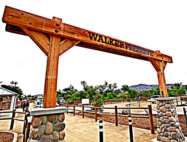 |
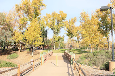
| Artist picture of Walker Preserve entrance (Walker Preserve Trail Santee) |
 |
| Image - Google Earth |
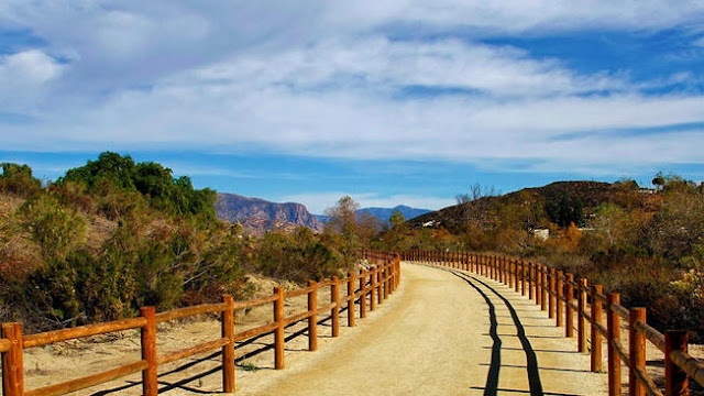
My wife and I visited and hiked this beautiful Walker Presere trail back in April 2018. We actually came into the Preserve's trail from the backdoor direction of the Lakeside area off Riverford Road and walking west towards Magnolia where this beautifully crafted cobblestone foundation and ranch-styled entrance is located. A lot of effort and talent have gone into this trail layout and design which is rather simple and easy to navigate. We saw quite a few families out walking that day. The temperature was perfect, sunny warm, but with light cool breeze. The sky was clear and blue without haze. All in all a very pleasant day. I wish more municipalites would excercise more forethought by identifying other abandoned industrial properties within the boundaries of the cities which are presently nothing more than wastelands of collateral damage and make Nature Preserves out of them. Access to nature would be closer to residents and this would ease some presure off the National Forests and Parklands which are often times overwhelmed by visitor traffic.
 |
| Image - hikingsdcounty.com |
One impressive feature I liked along this public walk was the design layout and materials used in the construction of the trails. A lot of forethought, care and great physical effort on the part of paid workers and volunteers went into this project. I love the post and lodgepole fencing. The walk has a remarkable cleanliness about it, something unusual indeed in our modern times of tattered run down public places. There are dog watering stations, poop bag dispencers at no cost. Bicycle tire pump stations for emergency.
 |
| Image - City of Santee |
 |
| Image - East County Magazine |
The East County Magazine journal published an event that marked the fourth consecutive year that the Takeda Pharamceuticals company again partnered with the City of Santee and The San Diego River Park Foundation to beautify the Walker Preserve trail with over 6,000 native trees. Along with the help of locally recruited volunteer helpers, they planted a mix of important native habitat trees and shrubs. The project's goals were to support many necessary vital ecological functions with the correct plants along the trail, which included specific native plants which would provide the local wildlife with food, shelter and nesting areas, attract pollinating insects, filter the areas water runoff during rainy season storms to prevent soil erosion and sediment from being transported into the San Diego river bottom. As a plan it all had many great goals.
 |
Image - Walker Preserve Trail Santee (February 2018)
Workers from Habitat Restoration Sciences Inc. are doing irrigation work |
 |
| Image - Walker Preserve Trail Santee |
Back early this year in February 2018 a large portion of irrigation infrastructural design and installation work was accomplished by the people from Habitat Restoration Sciences Inc. These photos I'm using above & right are from the Walker Preserve Trail Santee's page on Facebook. They appear to be setting up the drip irrigation pipelines which utilizes recycled effluent water I assume from Santee Lakes. The tubing used is much larger than normal dripline. I'm hoping they have a plan for later removal or perhaps installing some strategically permanent located deep pipe irrigation portals which will direct water deeper into the earth and away from the surface for the more water loving trees like Sycamores & Cottonwoods higher up away from the river bottom. Both trees will send rootsystems to a little over 20' deep, but that will take some time. It is also necessary that mulch be applied (which they seem to have done here with the drip) generously on top of the soil to prevent evaporation and allow for more rootsystem surface soil cooling which is necessary for proper rooting & above ground tree or shrub foliage development.

Deep-pipe irrigation is a no brainer and would not be that complicated to duplicate from many of the commercial designs available on the market today. I'm certain the city of Santee has capable employees who've got the intuitive talent for inventiveness to replicate such designs from raw materials available from any irrigation supply depot. It will also be imperative to stop the use drip irrigation as a permanent feature which does nothing more than keep plants on a form of life support. Left too long and any attempt to remove the drip from the plants which will lack the deeper mature root infrastructure in a hot dry climate will be fatal. I wasn't overly impressed with the layout I saw in some places. I did however see some attempts at the deep pipe irrigation which were the simple hand bucket watering tubes along the pathway (like the illustration above), but these had mostly failed as 80% of the Coast Live Oaks and Canyon Live Oaks had died. More on that later on down the page.
 |
| Image - Mine April 2018 |

I certainly applaud the effort of installing proper irrigation, but it needs to be done in the right way and not be a permanent fixture with native plants. Most of this setup was on the south side of the trail between the fence and river channel below. Also commendable is the use of grey water for the irrigation, although that too depending on quality may cause too much salt build up over time which is something most plants (not just natives) will not like. Unfortunately one of the bigger problems I saw was the puddling from too much water or it also may have been a problem of soil compaction because of years of heavy truck travel by the heavy construction machinery by the old sand dredging operations which required dumptruck movement long before trail preparation prior to the tree planting a few years back. Some type of surface deep till may have be necessary to break the soil concretion. As it stands now, this has caused bad soil percolation for the water infiltration. Most of these native plants I saw were developing root rot as a result of the standing puddles of water which could be seen by how many plants had dead or moldy foliage. Plant root systems need to breathe. While they do indeed exhale oxygen, their roots breathe in oxygen. The other nonsense thing you can see above is where someone actually put a prickly pear cactus on drip irrigation. Never never EVER put any cactus on drip or any other irrigation. Just dig a dry hole and partially bury the cactus pad or cholla joint in the ground and walk away until next rainy season. There is enough energy and moisture within the succulent cacti tissues to trigger a root growth response. It does not matter if there is no water present in the soil, because the cacti's genetics will trigger an App to get started with the stored food and water already present within the pad long before rains come. When they do come the plant will be ready. Watering simply encourages rot at planting time.
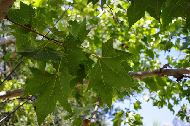
Troubles with their California Sycamore Identification by the Experts
 |
Image Mine 2018
This is a real life image of a true California Syamore |
 |
| Image - Mine 2018 |
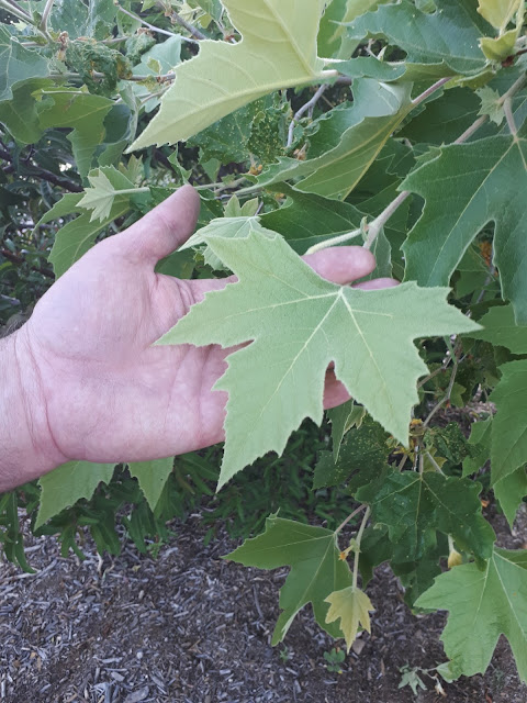
Yup, this is a genuine close up of the California Sycamore's leaf pattern. Not all Sycamore leaf patterns are identical, even though the characteristic puzzle pattern of their bark can seem similar. This is why I'm holding out my hand with wide spread fingers in the top photo next to the leaves to illustrate the point. Both of the native Southwest's Sycamores, the California (Platanus racemosa) and the Arizona (Platanus wrightii) Sycamores, have this characteristic spreading finger pattern which sets them apart from other Sycamore with more maple leaf patterns. Although a main difference between the two is that the Arizona often will have a larger leaf size. This placement of the incorrect or wrong type of tree within a native plant sanctuary (which is supposed to be for educating the public) has always been a major annoyance to me. I've written about this previously regarding the San Diego Wild Safari Park near Escondido and the Padre Dam location west of Santee in the Mission Trails Park. The gross negligence at the Wild Animal Park is actually inside of the California Coastal Sage Scrub and Chaparral exhibit. You may read about their blunder (HERE). I guess I expect more from a group of professionals who are hired because they no doubt claimed to be experts on their resumes as having credentials and initials behind their names like some business card. Here below is a Walker Preserve mistake.
 |
| Image - Mine 2018 |
 |
| Image Mine from 2014 |
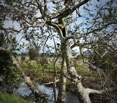
The location of this photo above is almost exactly 100 yards east of the spot where the true California Sycamore was planted near a wooden bridge. This tree above is not a California Sycamore, but rather more likely the hybrid known as London Plane Tree, which is a cross between American Sycamore (Platanus occidentalis) from the eastern USA and the old world Eurasian Sycamore (Platanus orientalis). It's own scientific name is Platanus acerfolia, 'acer' meaning maple and 'folia' from where we get the english word for foliage. So it's a Sycamore with mapleleaf-like leaves. BTW, the photo of Sycamore leaves to the top right was taken in 2014 at the Wild Animal Park within the Chaparral exhibit. The photo below was taken in April of this year 2018 at Padre Dam and there are many more of them which were planted in the parking area, even along the old former Mission Gorge Road through the gorge. And just so that people reading think I'm being picky or critical for the sake of being critical, here is a research link exposing the fact of danger of pure genetic pollution of the Platanus racemosa species.
Evidence for genetic erosion of a California native tree, Platanus racemosa, via recent, ongoing introgressive hybridization with an introduced ornamental species
 |
Image - Mine April 2018
Misssion Trails Regional Park - Padre Dam |
I suppose I expect far more from the hired people who are supposed to be Biology-Botany Experts who were there to provide restoration oversight on this and other official area project areas. These glaring mistakes were not just reserved to Mission Trails, Mast Park # Walker reserve, but also the San Diego Safari Park (formerly Wild Animal Park) at their native California Chaparral exhibit with the photo below at the native SoCal Oasis setting. Again, in my understanding, there are no better experts than those employed by the San Diego Zoo. Or so I thought, take a look below. To be honest, I'm thinking many of these people are relying on commercial nurseries who sell protect generally to an ignorant gullible public unaware of what they purchased. The hired landscape Laborers also will rarely pay attention, so the criticism goes right to the top and lack of responsible oversight for something so important as education and restoration/preservation.
 |
Photo Mine from 2014
San Diego Safari Park - SoCal native plant exhibit |
The Last Word on Hybrids. Apparently Others Like Nature Conservancy Have Taken Note.
 |
| Western Sycamore tree © Greg Golet |
Platanus racemosa + Platanus hispanica = Hybrid Sycamore
Unraveling the Mystery of the Western Sycamores that Weren’t
 |
| London plane tree © Greg Golet |
Coastal Sage Scrub & Chaparral Exhibit @ San Diego Safari Park
The mis-identification of plants was not the only gross error. Below is a Coastal Live Oak where I'm holding up the sign which someone pulled up or kicked over. While this particular oak tree looks healthy and doing well, the majority (perhaps 80%) of the other oak trees are dead from improper installation placement at planting time, no thick layer of mulch provided at planting time and maintained year after year to provide protection from the sun's intense summertime effects. Even this healthy looking Coast Live Oak should have a regular generous layers of fresh mulch provided on a yearly basis. This would not be difficult to come by and could be acquired for free.
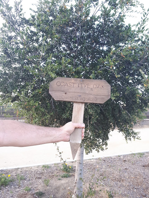 |
| Image - Mine April 2018 |
 |
| Image mine from July 2014 |
While it was commendable that they did originally place a layer of bark mulch within this planter at time of planting the Coast Live Oak, this should be a regular maintenance practice which should be done every Spring because the bark will degrade as it should. As it does, the nutrients are also fed back to the oak by the microbes digesting these materials. This region's tree trimming companies have to come past this point either by way of the Santee Landfill to the west or by the eastern route to a composting business off Hwy 67 at the mouth of Slaughterhouse Canyon near to the San Vicinte Reservoir. They must pay a fee to dump their loads, but dumping on the trail system's maintenance yard site (where ever that is) would be perfect & free (for both parties). Let me explain why the root system cooling is so important to the health and vigor of native trees. In nature an Oak's acorn is taken by a scrubjay and purposely planted underneath shrubs of chaparral. So it has shade and cover. While people may look at so-called Oak Savannas up in central and northern California or even locally in areas of Santa Ysabel or Mesa Grande and find them rather a romantic setting, those older oaks did not start out on bare hot dry soil or in grasslands. An acorn and it's seedling would never have survived the intense summer heat. Those areas were once chaparral covered or at least interior sage scrub covered when those oak acorns germinated. The American Indians later came along and often burned off the chaparral sage scrub, later the Spaniards did the same thing for their cattle to graze and even later the white Europeans from the British Isles who started their own cattle operations kept the area cleared out from shrub encroachment, hence grasses moved in. Most of those grasses are non-natives annuals (as opposed to deeper rooted native perennials) with most being non-mycorrhizal when it comes to their root zones. This scenario works against oaks becoming established. They require mycorrhizal soils.
 |
| Image mine from 2014 |
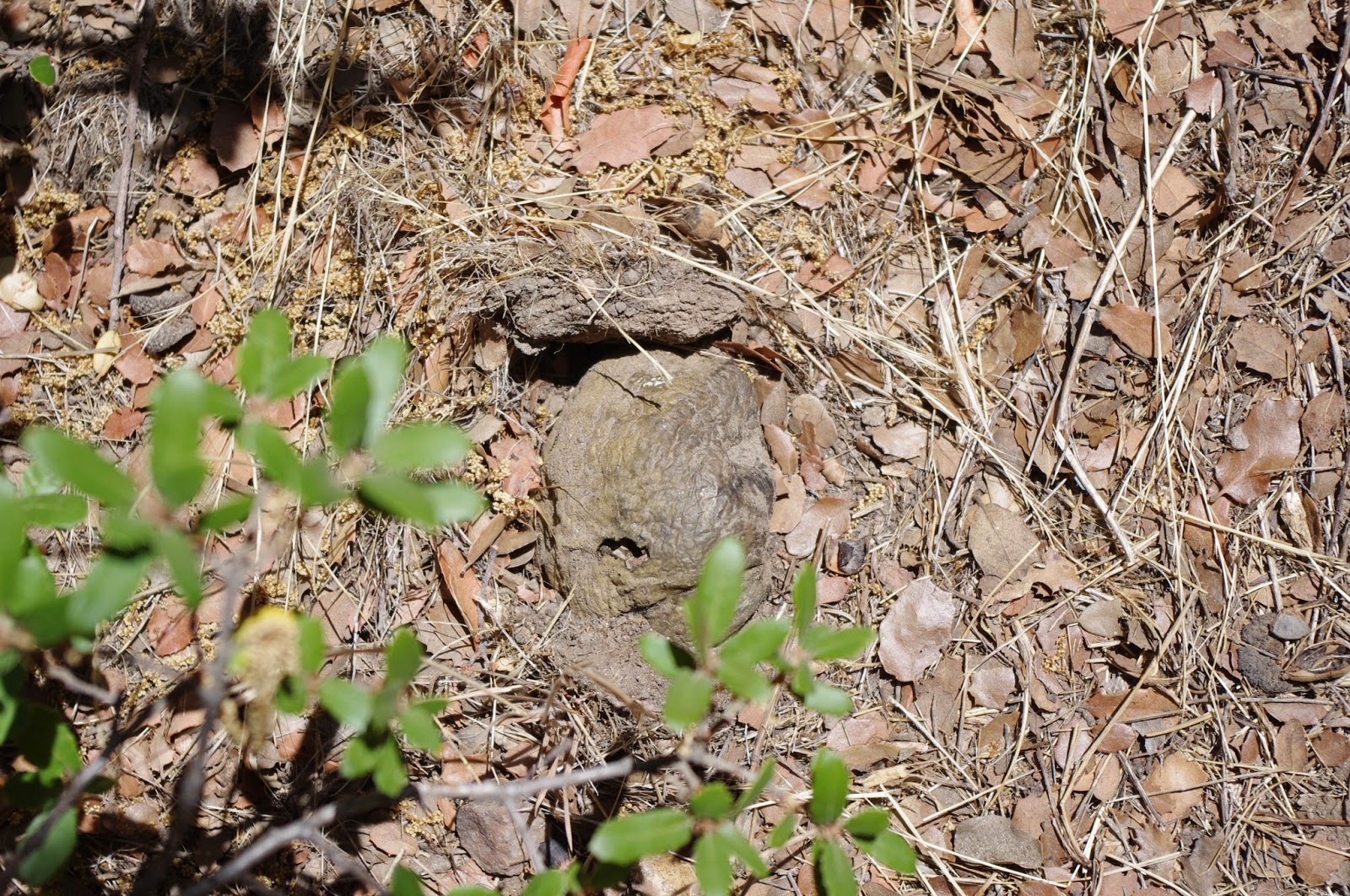
Oaks need a microbiological soil profile rich in ecto-mycorrhizal fungi. In the particular truffle photo above, this came from an area just south of Julian off Hwy 79 at the Desert View Overlook. Take note of the scrub oak's leaves in the photo. These truffles were colonized on the scrub oaks, Cuyamaca Cypress, possibly Manzanita and even the Chamise or Greasewood. Tough to see the truffle in the top photo isn't it ? I was deliberately looking for them and found it. Most people would have stepped over it. This was along a narrow trail pathway created by tourists exploring the viewpoint and the second photo was taken after I cleared a little of the surrounding debris away from the truffle so it could be more clearly viewed in another photo. Otherwise they just look like rocks. This species of truffle is called Pisolithus tinctorius or just P.T. Mycorrhizae. For me it's the single most important fungi to use in colonizing any oak or pine at planting time and I highly doubt the volunteers who were organized for the Walker Preserve Project were told anything about this. This particular fungi will help an oak tree survive hot dry sites. In fact they are designed for that specific purpose. It's like putting Hooker Headers on a 1960s Muscle car which can improve power and performance. The presence of mycorrhizal fungi on a plant's root system increases water and nutrient uptake anywhere from 200% to 800% depending on the soil.

Another key is the right host with the right species of fungi can make a difference. Now pay very close attenton to reasons for mulching with bark. This data below comes from a hollistic dryland farmer named Gabe Brown (5000+ acre farm in North Dakota) who uses absolutely no science-based synthetic fertilizers, nor pesticides, and only utilizes the practice of maintaining a multiple perennial species (20+) of native prairie cover crops to nurture mycorrhizal fungi and other microbes which create soil aggregates which further allow better soil breathing and percolation of rainwater with no runoff. Notice the benefits he lists.
Importance of Soil Temperature & the effects on Plant Root Systems
140 degrees, soil bacteria die
130 degrees, 100% moisture lost through evaporation and transpiration
100 degrees, 15% moisture is used for growth, 85% moisture lost through evaporation and transpiration
70 degrees, 100% moisture used for growth
Very important link for the using of mulches within an urban landscape in hot climates
Soil without Biology is simply Geology

The illustration above is about the effects of vegetation cover over the soil, not the type of vegetation, just the fact it exists and in what density. Even weeds provide a measure of cover over the soil. We may not necessarily like the weeds, but that is the purpose and function of many ruderal type weeds. Cover soil quickly and in abundance. Then through a succession of more desirable plants from perennials to shrubs and maybe eventually trees, this is how Nature works in the wild although probably not at the speed humans desire. fact that weeds have actually become a problem is not nature's fault but rather human ignorance on how nature works. Now armed with this knowledge landscapers and habitat restoration planners can actually accelerate the growing process, not with weedy annuals, but with mulch which maximizes how water is used and improving plant growth and survivability, because higher soil temperatures have been greatly reduced which benefits soil life. In the age of Global Warming alarmism, this kind of knowledge needs to be taught more and made a major part of discussion. Sadly, it seems that political ideology and demonizing opponents as to blame for Climate Change is nothing more than one side's attempt at grabbing power rather than actually helping nature. This is a major reason I've pulled out of following most all Environmental Organizations today. Best thing I can contribute here is helping individuals learn how Nature really works and help them make practical application in their own gardens and landscapes and possibly their favourite habitat restoration projects.
Examples below of plantings that failed which could have been prevented
 |
| Image - Mine April 2018 |
 |
| Image mine from 2018 |
Okay, yeah, yeah, yeah, I crossed over into the Planet of the Apes forbidden zone into the *cough-cough* sensitive habitat area, except there was nothing there that was sensitive unless Yellow Star Thistle has suddenly become a protected endangered plant species. Out of maybe several dozens of oaks planted, there were maybe three or maybe four that have survived and even these were in pathetic condition, just barely hanging on. The data on soil temps & root interactions up above are no joke. Soil temperatures will dictate how your plants will use the water you provide them. Doesn't matter if you irrigate regularly, it's soil temps that matter. I found this out back in the 1980s when I planted pines and oaks in areas where soil was shaded and others where nothing but bare soil surrounded the saplings. Foliage often looked droopy and dull at the peak on a hot day in the exposed sites and the trees where soil was always shaded seemed to out perform those in sun. Even when I tried to compensate with more watering of the expose trees, nothing changed because the bare exposed ground still heated up. It wasn't till I trucked down free pine straw and oak leaf mulch from people's yards up in Idyllwild where regulations forced people to rake up debris because of fire hazard, did I see a complete turn around with the trees in the full sun. Now look at this Canyon Live Oak below.
 |
| Imafe is mine from April 2018 |
 |
| Image - Mycorrhizal Applications |
This oak sapling is a Canyon Live Oak, (Quercus chrysolepis). There were signs identifying them, but the photo I took had glaring sun so I won't post it. I could actually clear away the weeds and other competition around this tree's trunk, drill several three inch deep holes around the tree within the rootzone close to the stem and pour in a small amount of powdered spore dust formula from MycoApply (endo-ecto) and mix in with it the chocolate brown powder from the wild truffles of the P.T. Mycorrhizae I just showed you up above in summer along with water and by next Spring, this tree will have at least a foot and a half new stem growth on it's central leader bud (half that on branch tip stems) and the leaves will be triple or more the size you see here in the photo. The reason I use the MycoApply powder is because it contains humic acids (derived from Lignite extracted from Brown Coal) which are good at root growth stimulation which is needed for spore germination. There are several species of spores in the powder, but I also add the fresh wild P.T. spore dust powder because I've found I have better chance of colonization and truffle formation will usually appear one month after application. The first truffle will only be the size of my thumb and you will not notice any difference in foliage until next Spring. But at least you know it has been colonized. Then by next Spring season you will see softball sized truffles near the tree. Sometimes as far away as 10 or 15 foot away.
 |
| Image by KFMB San Diego |

What I would like to see is an ecology teaching signage tool like the one above, for helping the public to understand how things work for real out in the wild. That's why I think a sign explaining the planting and microbiological activity going on under the ground would be perfect. Maybe it would encourage the locals to replicate these techniques in their own yards with native plants and dumping the scientific indoctrination of using synthetic chemical junk science pushes for maintenance and care found at the local Lowes or Home Depot down the streets. I'm tired of experts blundering and getting things wrong at these public funded Parks. You folks do know what an Expert is right ? An Expert is someone who use to be PERTinent, but no longer is. Hence Ex-Pert. No longer relevant, no longer germane, etc. That's why our planet looks the way it does because leadership has soured. And for the record, I'm not just being critical to be critical and point out flaws. I understand on social media sites many people do this for the sake of sport all day long. I actually applaud the great effort of the volunteers and all their hard work, but I don't want their efforts to lose, I want them to win. Really I'm not all that mean if you get to now me, I'm really just a soft warm fuzzball. Okay, but just one more critical note about cottonwoods at Mast Park.
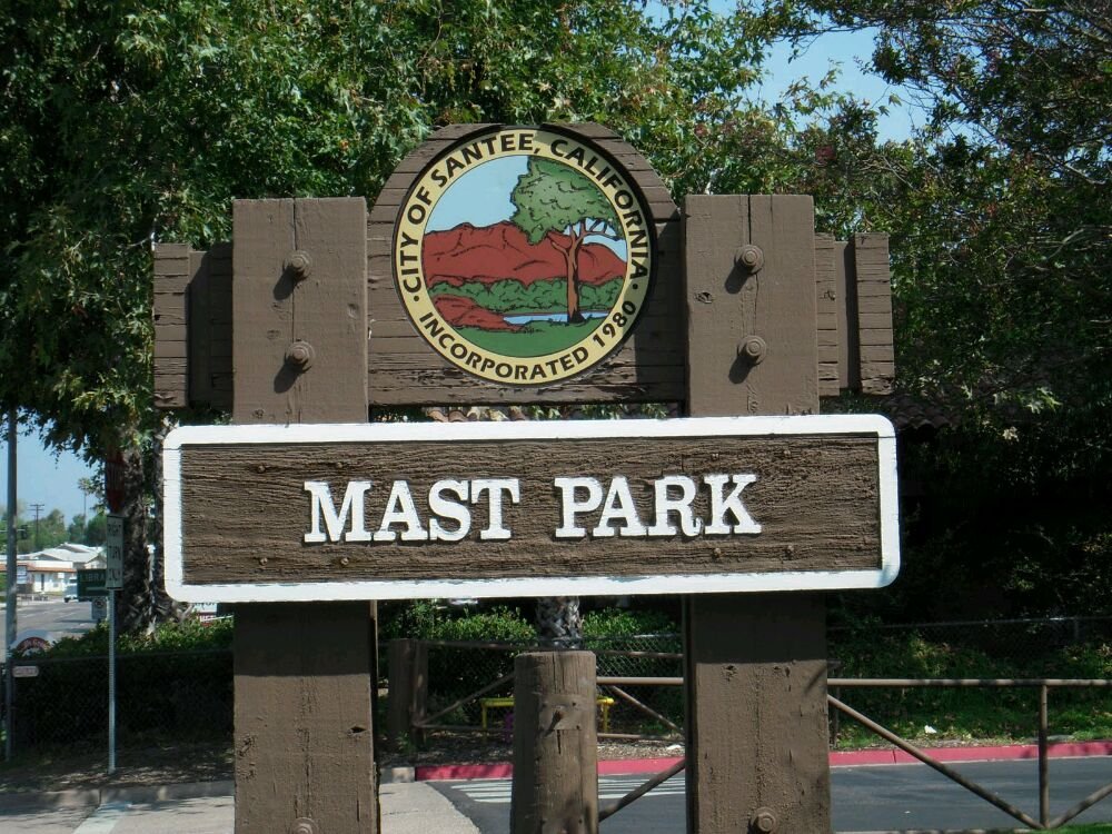
Santee's section of Riverwalk known as Mast Park
 |
| City of Santee |
The link above under the beautiful trail photo are from the same author and photographer, Russel Ray. He really captures the nice layout and construction of those who planned this part of the San Diego Riverwalk. And it's not cheap, it took a lot of skilled craftsman to do it all right. One of the things I love about most of the riverwalk pathways is that they are very easy for anyone to walk and not tire out. The place really is beautifully done. However as usual, I tend to critique things based on the plant choices used. In this era of strict native plants only and intolerance for anything exotic, I'm actually surprised and blown away by the glaring mistakes by the so-called native plant experts. There are as I mentioned above, two main foundation or cornerstone tree species historically along this river floodplain's river course. Fremont Cottonwood (Populus fremontii) & again California Sycamore (Plantanus racemosa). Let me just focus now on the Fremont Cottonwood trees I saw at Mast Park. To be truthful, the only Freemonts I saw were in the riverbed and along the pathway at the riverbed's edge. The others which were planted within the park's infrastructure and recreational sport areas are a back east cottonless hybrid known as Carolina Poplar (Populus x euramericana) - which is a hybrids of of both Eastern Cottonwood (Populus deltoides) from eastern USA and the Black Poplar (Populus nigra), which is native to Europe. Of course they are also male, hence no cottony seeds in Springtime.
 |
| Image - Wiki-Commons (Devindad 2012) |
 |
| Image - Sam McNally |
The photograph above is a bridge at the entrance from the parking lot which takes you into Mast Park. The photo is facing east and as you walking across the bridge and look to your right in the dry wash, you'll see hundreds of little cottonwood suckers which have come off the roots of the large Cottonless Cottonwood hybrids which travel 50 feet or more looking for water and suckering with new sprouts along the way. Same type of underground suckering habit Quaking Aspen have as they form acres woodlands from the same single tree. I never liked that about the Cottonwood hybrids when I lived up in Anza California. Back in the early 1980s when I was first introduced to them, neighbours everywhere in the surrounding area cut 10' branches from a friend or neighbour's tree and stuck them in the ground with drip irrigation and they rooted easily. Many people back in the 1970s were purchasing these mail order miracle trees which turned into giants in just a few years with the other selling point being they did not produce cottony seeds which was marketed as an annoyance. One way I found to tell the difference between a native cottonwood and the the one's from the back east hybrid was that the Cottonwood leaf galls were present on native Fremonts, but never the hybrids. The insect itself is an aphid called Pemphigus which creates the gall at the leaf stem. I never saw any harm to the cottonwoods ever and apparently there is a measure of chemical hormonal communication between the aphid and host which helps create the structure and increases more water and nutrient uptake. It may also trigger a boost to immune system, much the way certain species of mycorrhizal fungi do in their hosts through chemical message signaling. Believe it or not, it's the same with our gut bacteria.
 |
| Image - Sarah Turner 2012 |
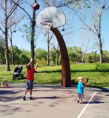
When I came out for a visit in April of this year 2018, I noticed the defoliated state of the hybrids as compared to the healthy looking native Fremont Cottonwoods by the river like the photo above and the one below. This is one of the other reasons I never liked the Cottonless Cottonwood hybrids out west, they just don't do very well and are on average from my experience short lived, about 30 years. Fremont Cottonwoods can live 130 to 150 years old by comparison. Unfortunately most of the Anza residents who wanted instant tree later found this out too late. The cottonless tree is great when young, but as it ages so do it's water requirements and out west water is an issue. The cottonless hybrids are also more suscepitble to various blight and other rot diseases which will sometimes cause half of the tree to die off. Take note of all the crown gall infections in these foreground cottonwood hybrid trees beyond the basketball hoop.
 |
| Image - Leslie Pantazis 2014 |
But even looking here through these trees and beyond the basketball court, can you see the big contrast between these hybrids in the foreground and the lush foliage of the native Fremont Cottonwoods well into the distance ? The other issue with these Cottonwood hybrids is they are more susceptible to the agrobacterium tumefaciens (same organism used by geneticists to fabricate GMOs) which causes the tumor-like features on the trunk known as Crown Galls. This may be another reason for the lack of foliage where the grotesque gall formations may be restricting water and sap flow to the upper higher reaches into the tree's leaf canopy. I've never seen this with the native Fremont Cottonwoods.
 |
| Image - Central Arizona Land Trust |
 |
| Image from River Partners |
This scenery above is the W Diamond Ranch in Skull Valley Arizona. This region is one of my favourites for huge Fremont Cottonwood specimens. There are numerous ancient specimens of this native tree which are giants over there in Central Arizona. You can see in the above photograph the size of the trees by comparing their size scale to the cattle. Very few such large examples of Fremont Cottonwood exist along the San Diego River corridor today and it wasn't always this way. Interestingly, if you ever view old historical photographs of Santee or Lakeside (especially Lakeside) you'll see an entirely different reality. For one, the water table was closer to the surface than today. In fact if we take the Walker Preserve as an example, the surface of the riverbed was much closer to the present hiking trail, with water being only a few feet from the surface instead of 30+ foot below. There were no major population centers sinking wells, damming river valleys etc to capture and take water at will. Remember in those old western movies where a pioneer family would stake out a claim for land to homestead and aside from land clearing, the father/husband would dig a ten foot pit and line it with stone or brick and call it a well ? You couldn't do such a thing today. The photos of Lakeside which have flashed around the internet lately intrigue most people who are interested in the settlements, the Lakeside Inn and Lindo Lake or old photos of where the railroad once existed. Those things are kool, but I'm generally more intrigued with the extensive native riparian forests which existed there. The trees (Sycamores & Cottonwoods) stand out as giants with dense stands of willows along the river's edges. The older original riparian forests would have been much greater than the old photos reveal because much of these photographs were taken long after farmers and ranchers came into the area and started to eliminate the native vegetation in order to grow crops, plant orchards or graze cattle. The graphic at the top right here illustrates just how far down a Fremont Cottonwood giant will go down in search of water. Take note that under ideal floodplain alluvial soil conditions, they may grow to a depth of 10 meters or 32+ feet down into the soil. And the same depth average is with Sycamores, but the average for both is probably 20+ feet. Further east however into the El Monte Valley a controversy is brewing over a proposed sand mining operation.
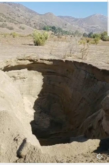 |
| Video capture image by Billy "Lakeside" Oritiz |
This pit was dug up by heavy equipment the last week of October 2018 by the owner of the Sand Mining operation for sand sample testing. They went way down fairly deep, maybe 20 feet, but notice there is no water ? All the historical mining operations between El Monte Valley westward to the Mission Gorge Dam have greatly reduced and lowered the floodplain's water table. Large trees will find it tough to establish within such a changed environment. The only vegetation that even remotely makes it in the El Monte Valley's artificial channel created after the1980 floods are the non-native Tamarisks. However there is a way of bringing that water table up close to the surface and creating a lush riparian valley wide ecosystem along with an efficient effleunt water recycling system which would also benefit Lake Jennings water supply. More on the mechanics of how this could be accomplished in a later post. 😉
Some fun Links by others who've hiked the Walker Preserve.
GEOCACHING: Walker Preserve Trailhead
Hiking San Diego County: Walker Preserve Trail
GrahamCrackers: Hike #6 San Diego River Trail (Walker Preserve & Lakeside River Park)
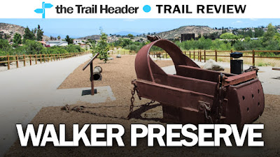 |
| Image - Tim Robertson |
And finally they have placed a piece of industrial history (Iron Dino relic really😉) into the Walker Preserve Trail landscape decor as part of the region's heritage. Indeed, those series of dredged and gouged out lakes carved into Santee's floodplain were mined of their 1000s of years old sand for San Diego County's 1950s/60s construction boom which started after World War II. There's even a signage board explaining the sand mine history of the area. But the miners aren't through yet unfortunately as the image and links below will attest.
El Monte Valley Sand Mining Controversy 😟
Industrial forces and big business interests are moving in to turn the El Monte Valley into another large industrial construction materials apocalyptic landscape. The El Monte Valley is one of the last almost unspoiled large floodplains in all of San Diego county and certainly the last one with regards to the San Diego River. West of El Capitan High School the entire river course to the Pacific Ocean has been butchered by sand and gravel mining operations for the past 100+ years. My next post is about the latest controversey and where to go for the most accurate info and who you should be listening to.
Stay Tuned! Okay as promised!
El Monte Valley Sand Mining vs Nature Preserve Controversy